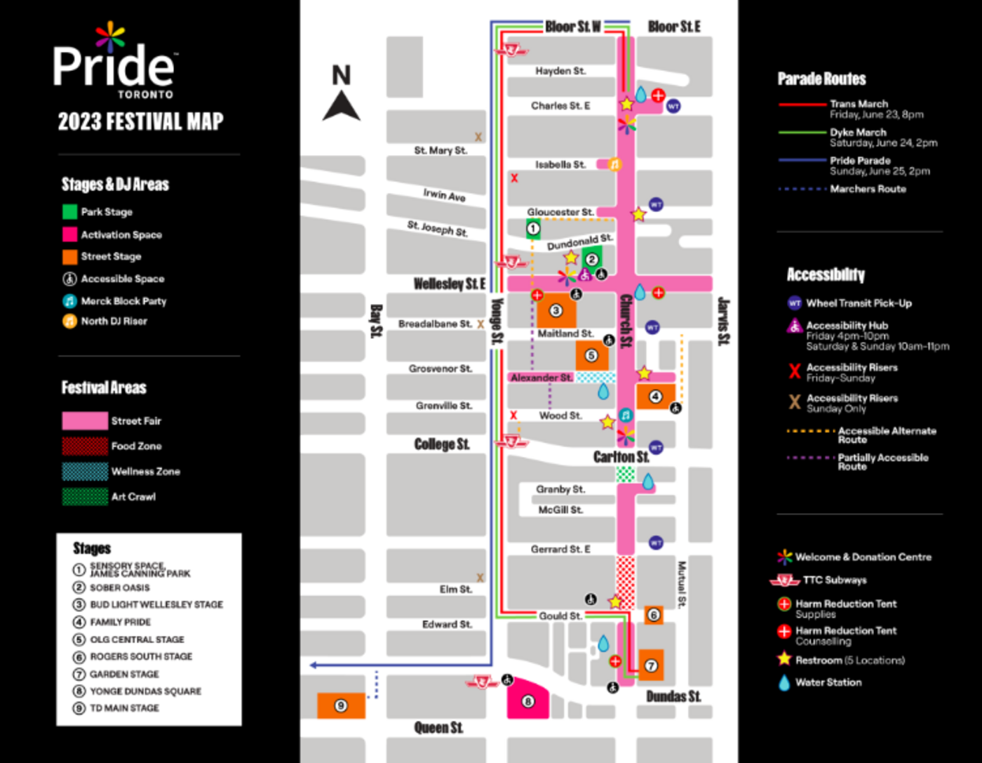
The Toronto Pride Parade route map and road closures for 2023
The Toronto Pride Parade is back in Toronto this Sunday June 25 and you'll want to make sure you don't miss out on the action.
Returning once again to celebrate the LGBTQIA+ community, the Toronto Pride Parade will start at 2 p.m. at Bloor and Church, making its way down Yonge Street and, for the first time, turning right on Dundas Street West.
The parade will run for about three hours, so arrive early to secure a good view, and don't forget to stay hydrated!
Afterward, you can head to this year's new main stage and beer garden at Nathan Phillips Square to keep the festivities going.
Apart from the recurring celebrations in the village, there will be musical acts from 6 p.m. to 11 p.m. at Nathan Phillips Square, with a special performance by electro-pop icon Lights to close out the Pride festivities.
Toronto Pride Parade Viewing Areas
While you'll be able to see the parade along the entire route, there will be six accessible risers and viewing stations where you can get an even better view of the floats and festivities.
Accessible risers will be located at the following intersections:
- St. Mary's St. and Yonge St.
- Isabella St. and Yonge St.
- Breadalbane St. and Yonge St.
- Wood St. and Yonge St.
- Elm St. and Yonge St.
There will also be a ground level viewing station at Edward St. and Yonge St.
Toronto Pride Parade Route Map
Toronto Pride has so far released a festival map that shows the route of the main Sunday parade as well as the Trans March (Friday) and Dyke March (Saturday).
The routes are basically the same except for the very end where the Pride Parade goes west on Dundas St.

Toronto Pride Parade Road Closures
As for road closures, Rosedale Valley Road from Park Road to Bayview Avenue will be shut down starting at 8:00 a.m. on Sunday, June 25. Additional road closures will start at 12 p.m. including:
- Park Road from Rosedale Valley Road to Bloor Street East
- Church Street from Park Road to Hayden Street
- Bloor Street East from Yonge Street to Ted Rogers Way
At 1:30 p.m., the following roads will be shut down:
- Bloor Street West from Bay Street to Ted Rogers Way
- Yonge Street from Bloor Street West to Queen Street West
- Dundas Street West from University Avenue to Victoria Street
- Bay Street from Queen Street to Dundas Street
All roads will re-open at 8:00 p.m. on Sunday.
Hector Vasquez
Latest Videos
Latest Videos
Join the conversation Load comments


